|
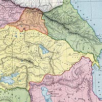
History, Geography and Ethnology Early History (700 BC - 700 AC) Karabakh or Nagorno Karabakh is the modern name of an area in the southern Caucasus.[1] The name of Karabakh, which originates from the Turkish and Persian, and literally means "black garden", dates back to Georgian and Persian sources from 13th and 14th centuries and refers to an Armenian principality which modern historians call the Kingdom of Artsakh or Khatchen.[2] Nagorny is a derivation from Russian, meaning mountainous. Thus, Nagorno Karabakh is "Mountainous Karabakh" and refers to the mountainous part of the region (roughly today's Nagorno Karabakh) which historically and geographically includes also the adjacent plain, sometimes referred to as Lower Karabakh (the districts of Agdam, Ter-Ter, Fizuli and Agjabedi in former Soviet Azerbaijan). The Karabakh region was inhabited by a people which in history is known as the Kura-Araxes-civilization, i.e. the population of a geographic area bounded by the rivers Araxes and Kura (see Map 1). The first mentioning of Karabakh dates back to the cuneiform script from the Uratuian King Sardur II of Armenia (763-734 BC). The document mentions the country of Urtekhini, which the Greek geographer, historian and philosopher Strabo (63/64 BC - 24 AD) called Orkhistene, Artsakh in Armenian. [3] It is unclear when the area was conquered by Armenia, but Strabo's history indicates indirectly that the country was already under Armenian rule in 189 BC. The ruins of the city Tigranakert, named after the Armenian King Tigran the Great (Tigran II), who ruled between 123 and 95 BC, was unearthed in 2005 under the supervision of archaeologist Dr. Hamlet Petrosyan, near present-day Agdam.[4] According to Strabo, as early as 100 BC, the people who lived in Greater Armenia, including Artsakh and Utik, spoke the same language, namely Armenian.[5] The name Urtekhini is closely related to the Armenian name, Artsakh, which in turn seems to be related to the name Orkhistene which Strabo used for the area.[6] The Armenian historian, Movses Khorenatsi (5th century AD), states that the province of Utik was during the 4th and 2nd centuries BC, along with Artsakh, part of the Armenian Kingdom of Yervandouni, also known as Orontids. [7] Finally, according to the geography book belonging to the Armenian royal dynasty of Arshakounian (7th century) "Greater Armenia was divided into fifteen provinces, covering [...] Artsakh, Siunik and Utik."[8] One of present-day arguments aftoen mentioned by Azerbaijanis is that Artsakh historically belonged to Azerbaijan's predecessor, namely Caucasian Albania. Historical sources confirm, however, a different picture. The historians Strabo, Ptolemy and Pliny the Elder confirmed unanimously that the border between Greater Armenia (Armenia Major) and Caucasian Albania (corresponding to most of present-day Azerbaijan) consisted of the Kur river.[9] The fact that the River Kur is Albania's southern border (see Map 1) and Artsakh is located south of that river shows that there are no evidence that the area, at least until the late 4th century AD, belonged to Albania or any other state than Armenia. [10] However, we know that when Armenia, in the year 387, was divided between the Roman Empire and Persia, Artsakh, along with the Armenian provinces of Utik and Paytakaran, ended up in Caucasian Albania's rule, which in turn was a satrapy (province) under the Persian Sasanid Dynasty. This Albanian sovereignty, however, was quite brief and lasted roughly 200 years, more specifically until early 7th century. During the 4th century, Christianity began to spread in Artsakh and the area's population came to play an important role in the defense of Christianity as Armenia's state religion against Mazdean Persia under Sasanid rule. At the beginning of the 7th century, the Albanian satrapy is divided into several smaller principalities and Southern Artsakh and Utik created the separate Armenian principality of Aranshakhiks. The Armenian-Christian culture flourished in the second half of the 7th century and came to develop into a distinct Christian culture during the 8th century. Notes
1) Journal of the Society for Armenian Studies (JSAS), Volume 8, University of Michigan, 1997, p. 54. |
|
